1/6


Tactical GPS
1K+다운로드
6.5MB크기
3.00(18-04-2023)최신 버전
세부 정보리뷰버전정보
1/6
Tactical GPS의 설명
이 GPS 응용 프로그램은 위성 데이터를 사용하여 현재 위치에서 목적지까지의 방위 및 거리를 제공합니다. 인터넷 연결이 필요하지 않으며 산, 사막 또는 바다와 같은 장소에서 사용할 수 있습니다. 가고자 하는 장소의 GPS 좌표를 입력하기만 하면 됩니다.
GPS 신호를 올바르게 수신하려면 전화기에서 하늘이 잘 보여야 합니다.
주요 기능은 다음과 같습니다.
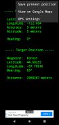
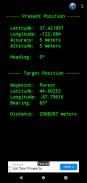
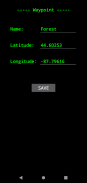
- 휴대폰 GPS 센서를 이용한 위도, 경도, 고도 표시
- 지리적 좌표는 십진법으로 표현됩니다.
- GPS 장치 및 Google 지도에서 사용되는 것과 동일한 WGS84 데이텀을 사용합니다.
- 지구 자기장을 기준으로 현재 방향을 표시합니다. 나침반으로 사용할 수 있습니다(0º=북쪽, 90º=동쪽, 180º=남쪽, 270º=서쪽).
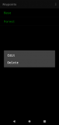
- 경유지 목록을 저장하고 현재 위치에서 목표 위치까지의 방위 및 거리를 표시할 수 있습니다.
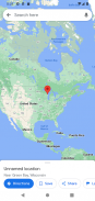
- 목표 위치를 Google 지도로 전송하여 다른 애플리케이션과 공유할 수 있습니다. 이 옵션은 인터넷 액세스가 필요합니다
- 배터리 사용량이 적다
- 항상 100% 무료입니다.
즐기다 ! :-)
Tactical GPS - 버전 3.00
(18-04-2023)Tactical GPS - APK 정보
APK 버전: 3.00패키지: org.z3studio.MilitaryGPS이름: Tactical GPS크기: 6.5 MB다운로드: 235버전 : 3.00출시 날짜: 2024-05-30 11:58:21최소 스크린: SMALL지원되는 CPU:
패키지 ID: org.z3studio.MilitaryGPSSHA1 서명: A3:E3:AD:20:7F:7F:38:EB:48:EA:06:2D:18:A5:44:C6:41:61:DF:B0개발자 (CN): Kenshiro단체 (O): 로컬 (L): 나라 (C): 주/시 (ST): 패키지 ID: org.z3studio.MilitaryGPSSHA1 서명: A3:E3:AD:20:7F:7F:38:EB:48:EA:06:2D:18:A5:44:C6:41:61:DF:B0개발자 (CN): Kenshiro단체 (O): 로컬 (L): 나라 (C): 주/시 (ST):
Tactical GPS의 최신 버전
3.00
18/4/2023235 다운로드6.5 MB 크기
다른 버전들
2.12
12/3/2018235 다운로드3 MB 크기


동일 카테고리의 앱

좋아할 만한 것...

English


